
About this story
On 27 August 1883 Krakatoa reached the climactic stage of an eruption in the Sunda Strait between Java and Sumatra, then in the Dutch East Indies. A sequence of immense explosions, ash, and tsunamis devastated nearby coasts; Dutch reports later recorded 36,417 deaths, largely from the sea. Barographs around the world registered the atmospheric pressure wave, and Rogier Verbeek’s 1885 study made the disaster a landmark of documented earth science.
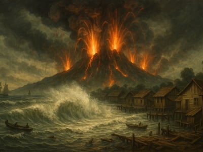
Krakatoa after the 1883 eruption in the Sunda Strait between Java and Sumatra.
On August 27, 1883, Krakatoa reached the climactic stage of an eruption that turned the Sunda Strait between Java and Sumatra into the center of one of the best-documented natural disasters of the nineteenth century. The volcanic island, then in the Dutch East Indies and now in Indonesia, had already shown serious activity for months. But on that day, a sequence of immense explosions, ash emissions, and tsunami waves transformed a regional eruption into an event measured in devastated coastlines, disrupted shipping, and observations that extended around the world.
A busy strait under a restless volcano
Krakatoa was not an isolated mountain on a distant horizon. It stood in a busy maritime corridor linking parts of the archipelago and serving routes used by local communities and commercial shipping. That setting mattered. When volcanic activity intensified in 1883, the danger was not limited to the crater itself. The surrounding sea, nearby coasts, and settlements across the strait were also exposed.
Reports from earlier in May 1883 had already pointed to renewed eruptive activity. Smoke, ash, and explosions signaled that the volcano had entered a more active phase. Even so, the full scale of what would happen on August 27 was not yet clear to residents, ship crews, or colonial authorities. In the nineteenth century, there were no modern warning systems for rapid volcanic escalation or tsunami detection. People responded with the information available to them: what they could see, hear, and infer from changing conditions.
The climactic phase on August 27 is commonly described through four major explosions. Together they marked the destruction of much of the island and the most violent stage of the eruption. The force of these blasts was recorded not only by witnesses near the Sunda Strait but also, indirectly, through instruments far away. The eruption drove pressure disturbances through the atmosphere, and barographs at distant locations registered the passing wave as it moved around the globe.
Explosions, ash, and a sea that turned deadly
Closer to Krakatoa, however, the most immediate danger came from the sea. Tsunamis generated during the eruption struck the coasts of Java and Sumatra. Settlements including Anjer and Merak were hit with destructive force. Coastal communities had little practical protection against fast-moving sea surges of that scale. Ports, houses, and shoreline infrastructure were highly vulnerable, and many deaths occurred not from falling ash but from the sudden arrival of water.
The official Dutch East Indies reports published after the disaster recorded 36,417 deaths, largely caused by tsunamis along the coasts of Java and Sumatra. That figure has often been repeated in later histories, though it is important to remember that such numbers came through colonial-era reporting systems, with the limits those systems could have in speed, reach, and completeness. Even with those caveats, the scale of loss was unmistakable. Entire coastal areas were damaged or erased, and the disaster reshaped local landscapes as well as local lives.
Counting loss and recording a global wave
For people in the region, the eruption was experienced as a chain of overlapping hazards rather than as a single moment. Explosions could be heard over great distances. Ash reduced visibility and complicated movement. The sea itself became unpredictable. Maritime navigation, already difficult in a volcanic emergency, became even more dangerous when coastlines were altered and familiar reference points disappeared. Communication moved slowly, and the task of understanding what had happened depended on scattered reports gathered after the fact.
That effort to document the event became an important part of Krakatoa's historical significance. Geologist Rogier Diederik Marius Verbeek later compiled observations and official records in his 1885 study *Krakatau*. His work drew together eyewitness accounts, administrative reporting, and scientific interpretation. For later researchers, it provided a structured account of the eruption's sequence and consequences. It also showed how nineteenth-century institutions tried to investigate a disaster that was both local in destruction and global in measurable effects.
From Verbeek’s study to a lasting scientific landmark
The eruption's aftermath extended beyond Indonesia. Fine material in the atmosphere and the pressure wave from the explosions were observed far from the Sunda Strait. This was one reason Krakatoa became such a major reference point in earth science. It demonstrated that a volcanic event in one region could leave traces in instruments and observations worldwide. In an era when global scientific networks were still developing, Krakatoa offered a dramatic example of how connected those networks had already become.
The island itself was also changed fundamentally. Much of Krakatoa was destroyed during the eruption. In the longer history of the site, volcanic activity did not end in 1883; in the twentieth century, Anak Krakatau emerged in the area, a reminder that volcanic systems remain active across generations. But the events of August 27 retained a special place because they combined immediate human catastrophe with unusually broad scientific visibility.
Why it still matters
Krakatoa remains a central case in the study of volcanic hazards and tsunami risk because it showed how one eruption can trigger multiple forms of destruction at once. The 1883 disaster is not remembered only for explosions or ash, but for the interaction of volcano, sea, coast, and population. That combination still matters wherever volcanic islands stand near settled shorelines.
It also matters because Krakatoa connected local disaster to global measurement. The pressure disturbances recorded by barographs around the world helped make the eruption an early example of a geologic event tracked through international observation systems. In that sense, Krakatoa belongs not only to Indonesian and regional history but also to the history of scientific monitoring.
Finally, the records left behind by colonial officials and by Verbeek's later study show how large disasters were documented in the nineteenth century. Those records are valuable, but they also remind readers to treat casualty counts and official narratives with care. They preserve essential evidence while reflecting the structures through which that evidence was collected.
More than a century later, Krakatoa is still cited because it brought together geology, human vulnerability, and the limits of warning in a densely connected world. The eruption of August 27, 1883, was a local event in origin, but its consequences reached across coasts, archives, and the atmosphere itself.
Timeline
- Krakatoa renewed eruptive activity
- Climactic explosions in the Sunda Strait
- Tsunamis strike coasts of Java and Sumatra
- Verbeek publishes the Krakatau study
- Anak Krakatau emerges in the caldera
What you uncovered
From Island Disaster to Global Signal
You didn't just… piece together a volcanic disaster; you retraced how one eruption was experienced locally but measured far beyond the Sunda Strait.
Krakatoa is often remembered for destruction close to the volcano, but it also showed how nineteenth-century science could connect distant places through shared measurements. Pressure waves recorded around the world turned a regional eruption into evidence that atmospheric events could be tracked globally. That made the disaster more than a local crisis: it became a reference point for how observation networks help people study hazards that do not stay confined to one place.
Barographs in distant parts of the world recorded the pressure wave from the 1883 Krakatoa eruption as it traveled through the atmosphere.
FAQ
What happened at Krakatoa on August 27, 1883?
On 1883-08-27, Krakatoa produced four major explosions during the climactic phase of its eruption in the Sunda Strait. The eruption destroyed much of the island and generated tsunamis that struck nearby coasts.
Where was Krakatoa located?
Krakatoa was in the Sunda Strait between Java and Sumatra in the Dutch East Indies, now Indonesia. The eruption affected settlements on both coasts.
How many people died in the Krakatoa disaster?
Official Dutch East Indies reports published after the disaster recorded 36,417 deaths. Many of the fatalities were caused by tsunamis along the coasts of Java and Sumatra.
Who documented the Krakatoa eruption in detail?
Geologist Rogier Diederik Marius Verbeek documented the disaster in his 1885 official study Krakatau. He based it on observations and colonial records.
Why was the Krakatoa eruption observed far beyond the region?
Barographs recorded pressure disturbances from the 1883-08-27 eruption at distant locations around the world. The atmospheric wave propagated globally and left measurable traces outside the immediate region.